


02 Nov Exploring Urban Spaces to Understand Air QualityStudents as Investigators of Their School Environment
At the IIS Luigi Cremona high school in Milan, students became urban researchers, combining field observation, digital mapping and collective exploration to investigate the environmental quality of the spaces around their school.
Looking at the city through a different lens
As part of the European research project MI-TRAP the Politecnico di Milano research group developed an educational and participatory programme with IIS Luigi Cremona, a secondary school in Milan. The initiative brought together students, researchers and environmental experts to explore the relationship between air quality and the urban environment.
One of the key activities was an experimental investigation of the open spaces surrounding the school. Rather than approaching the urban environment exclusively through maps or existing datasets, students were invited to become active observers, collecting information directly in the field and developing their own understanding of the spaces they use every day.
The activity involved 39 students from two third-year classes and was coordinated by researchers from the Department of Architecture, Built Environment and Construction Engineering (DABC) at Politecnico di Milano.
ACTIVITY N.1 – A walkshop to investigate the urban environment
On 25 March 2026, the students took part in a walkshop: a combination of walking, observation and collaborative learning designed to explore the urban environment through direct experience. Working in small groups, they investigated three interconnected dimensions of the area surrounding their school:
- Urban vegetation: identifying trees, shrubs and herbaceous plants, observing their physical conditions, spatial arrangements and potential problems;
- Public space: documenting different types of open spaces, examining surface materials, soil permeability, accessibility and patterns of use;
- Mobility: observing traffic flows and recording the different types of vehicles moving along selected road sections.
The objective was to encourage students to look beyond the immediate appearance of their surroundings and recognise the relationships between vegetation, urban surfaces, mobility and the quality of public spaces. For example, when observing vegetation, students were asked not simply to identify the presence of trees, but also to consider their growing conditions, the space available for their roots, the condition of their trunks and canopies, and their relationship with surrounding streets and buildings. Similarly, the investigation of public spaces focused on the materials covering the ground and their degree of permeability, as well as how people use these areas. These observations helped introduce the importance of soil characteristics and green infrastructure in shaping more environmentally sustainable urban spaces.
ACTIVITYn.2 – Turning observations into georeferenced data
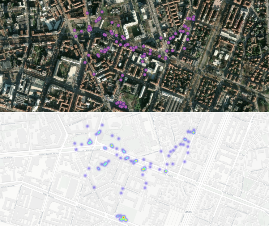
To support the fieldwork, students used Epicollect5, a mobile and web-based platform for collecting georeferenced information through customised digital questionnaires. The platform allowed each observation to be associated with its geographical coordinates and complemented with structured information, descriptions and photographs. This made it possible to transform individual observations into a shared and spatially organised dataset.
Each group followed specific observation protocols. For vegetation, students recorded at least ten elements, documenting their characteristics and any visible criticalities. For public space, they investigated at least three different types of spaces, focusing particularly on ground materials and uses. For mobility, they carried out five-minute traffic counts at two assigned locations, distinguishing between cars, motorcycles, bicycles and public transport.
The walkshop generated a total of 101 georeferenced observations:
- 57 observations concerning urban vegetation;
- 33 observations concerning public spaces;
- 11 observations concerning mobility.
ACTIVITY N.3 – Beyond physical data: understanding how people experience space
The investigation continued on 14 April 2026, shifting its focus from the wider neighbourhood to the school’s immediate surroundings and courtyard. While the walkshop had encouraged students to observe the physical and environmental characteristics of open spaces, this activity introduced another important dimension: the way people perceive and experience these places.
Through a collective mapping exercise, students were invited to represent their everyday experiences, identifying problems, criticalities, positive aspects and expectations concerning the spaces around their school. Two collective maps were produced, bringing together different perspectives and making visible aspects that are not always captured through conventional environmental surveys. Personal perceptions, everyday practices and individual expectations thus became part of the investigation.
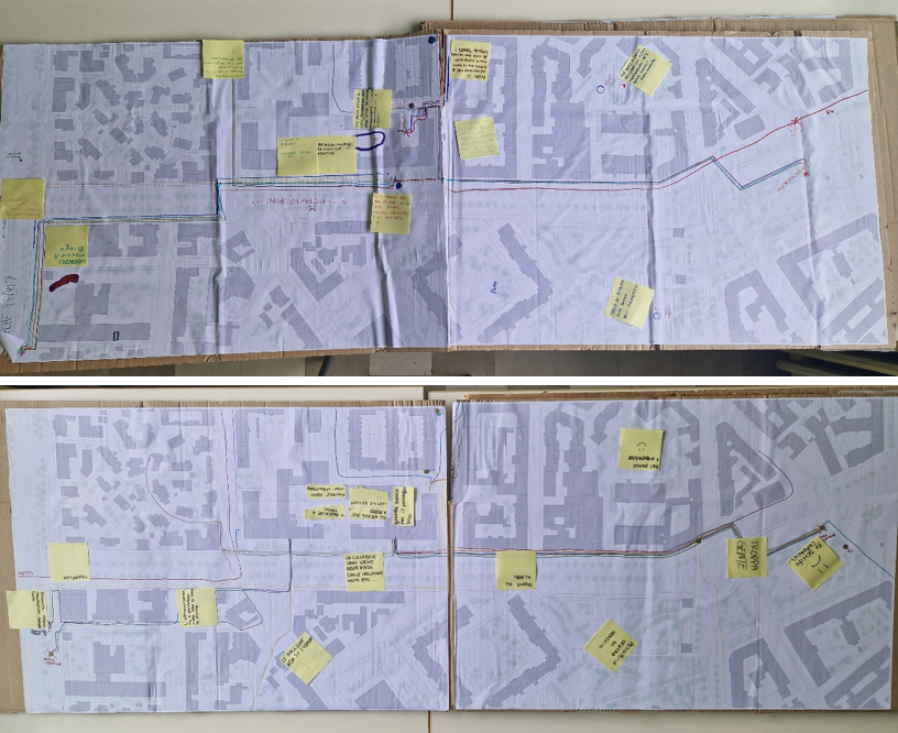
The activity highlighted the importance of combining objective observations with the experiences of people who regularly use a space. Understanding the environmental quality of an urban area also means understanding how it is perceived, accessed and experienced by its users.
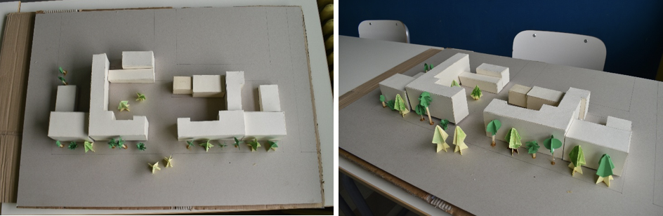
A further step involved constructing a three-dimensional physical model of the school and its surrounding spaces. The model was designed as a shared working tool for the subsequent design activities, allowing students to explore spatial relationships and communicate possible transformations through tangible representations.
From investigation to Nature-Based Solutions
The experimental investigation of the open spaces provided the foundation for the next stages of the educational programme, dedicated to Nature-Based Solutions (NBS) and the co-design of a greener and healthier school environment. By combining field observations, georeferenced data, collective mapping and physical modelling, students developed a preliminary knowledge framework of their surroundings. This will support the identification of opportunities and criticalities and inform the development of design proposals.
Within MI-TRAP, this approach is particularly relevant because the relationship between urban vegetation and air pollution is complex. Green infrastructure can contribute to improving environmental conditions, but its effectiveness also depends on how vegetation is positioned and designed in relation to streets, buildings and sources of emissions. Understanding the spatial configuration of an area is therefore an important step towards identifying appropriate interventions. The experience at IIS Luigi Cremona demonstrates how participatory investigation can contribute to this process, connecting environmental research with local knowledge and the everyday experiences of urban communities.
By becoming active investigators of their own environment, students learned to recognise the multiple factors that shape the quality of urban spaces and to understand how these factors interact. The approach also demonstrates the potential of involving younger generations in environmental research. Combining scientific methods with direct observation and collective interpretation can make complex urban challenges more accessible, while encouraging environmental awareness and active citizenship.
Ultimately, creating healthier urban environments requires both reliable scientific knowledge and an understanding of the places and communities where solutions will be implemented. Starting from the spaces we experience every day can be an effective way to connect these two dimensions.
TEAM MEMBERS:
Maria Stella Lux, Researcher at POLIMI-DABC – main responsible of the educational co-design activities with IIS Luigi Cremona, Milano
Stavroula Kopelia, PhD student at POLIMI-DABC
Cristina Musacchio, Research Fellow at POLIMI-DABC
Julia Nerantzia Tzortzi, Associate Professor at POLIMI-DABC – Head of the Research Group